The nearest major airport—Harry Reid International (formerly McCarran International) Airport in Las Vegas—is 170 miles from Zion National Park; Salt Lake City International Airport is 315 miles away. However, people are still willing to make the effort to visit Zion. The National Park Service study reported that about two-thirds of the area’s visitors listed Zion National Park as their primary reason for traveling to southern Utah.
It’s important to note that Zion, with 229 square miles within its boundaries, has been called the most crowded national park in America for its size, and there is a limited amount of parking inside the gates. When my husband Charlie and I visited in September 2022 to celebrate our 40th anniversary, we discovered it was an advantage to have our body clocks operating on Texas time. By arriving at the park each day at 6:30 a.m. (which felt like 7:30 to us), we were able to snag parking spots inside the park and get started on our day’s activities before most of the crowds arrived. When we left, our parking spots were quickly snapped up.
Lodging opportunities abound in the surrounding area, both near the park’s main gate and in towns a few miles away. Those who are willing to pay a bit more for ultimate convenience may want to stay in Springdale, Utah, which is situated right by the main entrance. Shuttles take passengers from various stops in Springdale to the main gate, where they can pay the entrance fee, check out the Zion Visitor Center and pick up shuttles to stops along the park’s main scenic drive. Both the Springdale shuttles and the National Park Service’s shuttles within the park are provided to park visitors at no charge. Those staying in Springdale can leave their cars at their hotels; those staying outside Springdale pay for parking.
We soon learned to appreciate the shuttle buses inside the park. They operate continuously, and we never had to wait longer than five minutes for a bus to arrive. Since 2000, only shuttle buses are allowed on the main road, Zion Canyon Scenic Drive, from May through November. This reduces both traffic and vehicular noise in the canyon.
There are many opportunities to enjoy the grandeur of the canyon. Some people opt to ride shuttles and get off at stops along the way to enjoy the views. Others embark on hikes of varying length. Some trails are short, paved and wheelchair-accessible, while others are longer and have significant changes in elevation. Many trails allow hikers to see hidden pools, “hanging gardens” (plants growing on the canyon walls), waterfalls and an assortment of wildlife. We saw mule deer, turkeys, chipmunks and even a tarantula during our time in the park.
The two most renowned hikes in the park are also the most challenging and the most dangerous, so we opted out. We saw many people of all ages, however, who could not resist the challenge. The Narrows, found at the end of a leisurely stroll along the banks of the Virgin River, begins where the canyon walls start to narrow as a result of a shift to more erosion-resistant stone. Adventurous hikers, many with rented water shoes and hiking poles, walk in the deepening river over slippery, uneven rocks to traverse The Narrows. In the area known as Wall Street, the canyon is only 20 to 30 feet wide, with sheer walls jutting 1,500 feet upward. Those who hike The Narrows report that it is an otherworldly experience.
A trip to the top of Angel’s Landing—a 5,790-foot tall, fin-like rock formation—is the most dangerous hike in the park, and is, in fact, one of the deadliest hikes in America. Since 2000, 13 people have reportedly plunged over the cliff to their deaths. I’m told that in places, the trail is no wider than a sidewalk, and there are no rails to stop people from falling off the cliffs; however, the National Park Service has installed sturdy chains along particularly precipitous parts of the trail. Crowds adversely affect safety, so beginning April 2022, visitors must obtain permits to hike to Angel’s Landing. Those who make it to the top must ascend 1,500 feet, but report a spectacular, 360-degree view.
To avoid crowds, Charlie and I decided to spend one of our days in the Kolob Canyons section of Zion National Park, which was no farther from our charming Airbnb cottage in Hurricane, Utah, than the main park. We were rewarded with stunning views of brick-red canyon walls and mountains in the distance. Although Zion Canyon is known for being more dramatic, we found Kolob Canyons to be a worthwhile side trip.
There are five national parks in Utah, often called The Mighty Five. Although Capitol Reef, Canyonlands and Arches national parks are farther east, Bryce Canyon National Park is only about a 90-minute drive from Zion. Many people, therefore, visit both parks while they’re in southern Utah. To get to Bryce Canyon, travelers go east on Highway 9 inside Zion National Park, taking a 1.1-mile tunnel that was blasted through the rock to provide a link between Zion, Bryce Canyon and Grand Canyon national parks. When it was completed in 1930, it was the longest tunnel of its type in the U.S. For safety, RVs and other oversize vehicles pay a fee to go through the tunnel, and traffic then becomes temporarily one-way. Unfortunately, this adds time to the commute for all travelers.
Although geographically close, Bryce Canyon is geologically different from Zion Canyon, with thousands of hoodoos, formed by the erosion of larger rocks. Some reminded me of castles, while others look strangely human. At points overlooking Bryce Amphitheater, visitors can see how the Silent City got its name. It’s also apparent why Ebenezer Bryce, a rancher and owner of the eponymous canyon, once remarked, “Hell of a place to lose a cow.”
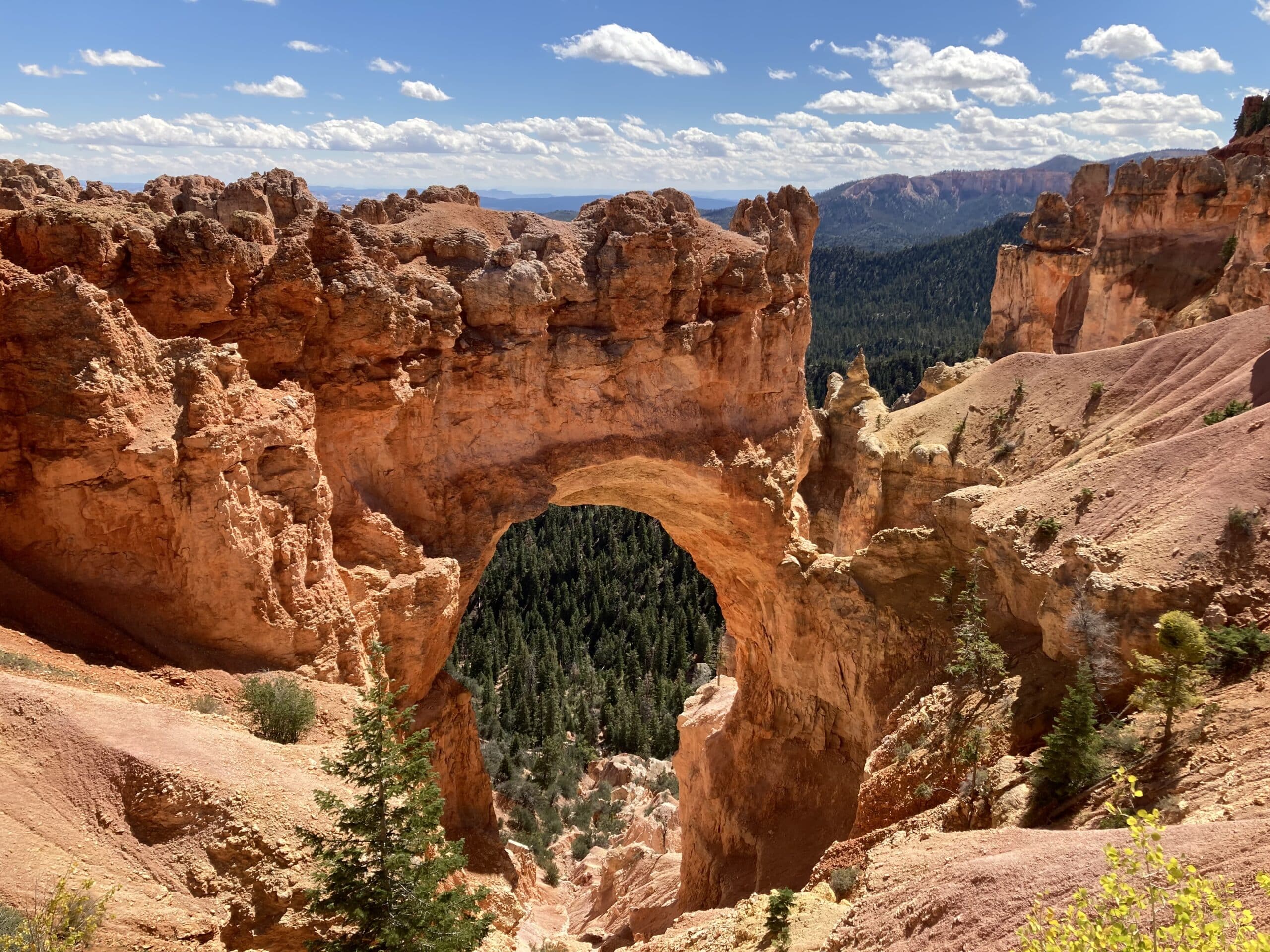
Charlie and I took the advice of our Lonely Planet guidebook and drove the entire length of Bryce Canyon’s main road and arrived at the south end, Rainbow Point (elevation 9,115) around lunchtime. There, we took in a seemingly endless view of the canyon floor, with mountains extending well into the distance. After a few photos and a picnic among beautiful bristlecone pine trees, we began the drive back. The guidebook was worth its purchase price for noting that all the scenic pullouts are on the right side of the road when traveling back toward the Bryce Canyon Visitor Center. We saw many of the same people at each stop! We were disappointed to discover a full parking lot near the flagship sites overlooking Bryce Amphitheater, but we drove the short distance back to the main gate, found a parking spot and loaded a shuttle. The shuttle buses go no farther into the park than the amphitheater, so we were glad we had driven to the more southern parts of Bryce Canyon National Park, including a spot overlooking the stunning Natural Bridge.
I confess that, before our trip, I underestimated these two magnificent national parks. However, both provided jaw-dropping views, agreeable weather, and scenic hikes. Visiting this spectacularly beautiful part of the country was an unforgettable experience. For more information, visit nps.gov/zion and nps.gov/brca.

Postcards Magazine
936-293-1188
PO Box 690
Huntsville, TX 77342
